Wednesday, September 26, 2012

Alaska Ferry

To save on driving all the way back home, we decide to take the ferries back to the Lower 48. Although we were warned to make our reservations way ahead of time, we made ours in Tok, Alaska  a month before leaving on the Alaska Ferry. Much to our surprise, we got the reservations we wanted and an outside berth to boot. It helped to be taking a route less traveled than the more popular Alaska to Washington state one, which fills up quickly. Our route was an Alaska Ferry from Haines, Alaska to Prince Rupert, BC. The next leg was from Prince Rupert on a BC Ferry to Port Hardy, BC which is at the northern tip of Vancouver Island.  After driving down the island to Victoria, BC. the final leg is taking a Black Ball Ferry to Port Angeles on the Olympic Peninsula in Washington state.

We start off early in the morning as the ferry requires 2 hour check in before departure. We are amazed at the wide variety of travelers they board... everybody from walk-ons, motorcyclists, people with dogs in large class A RVs, tour buses and even semi truck/trailers.
Vehicles and passengers boarding ferry

All are aboard and the ramp lifts up for departure


We pull away from the dock and are on our way homeward.


Once we are underway, we explore the ferry.  It has a large observation room as well as a place for tent campers on the deck and of course a cafeteria with a separate bar (it is Alaska).  We meet a wide variety of people on board. Everyone from well to-do neighbors of Sarah Palin to a high school girls choir on their way to a performance. The Alaskan Ferry system is much like the Greyhound bus system in the Lower 48.
Observation Room

Lighthouse at entrance of Lynn Channel


Our first stop is in Juneau, Alaska.  We are looking forward to going downtown to eating at the Hangar for halibut burgers and Alaskan Amber on tap, which we very much enjoyed there on our 2009 trip. Unfortunately, the ferry dock is now 15 miles out of town and transportation consists of an expensive round trip taxi ride. With cruise ships taking over the downtown docks, the ferries were forced to move further out of Juneau. There's a five hour layover,  so we decide to take a much needed nap instead (we're very glad to have booked a berth). Besides we discovered the cafeteria makes a very good seafood chowder.
Docked in Juneau, Alaska

We pass a cruise ship in the night


Petersburg, Alaska at dawn
At 5:30am we stop in Petersburg where a young mother we met gets off. We noticed her car full of Costco supplies boarding in Juneau. She says it's well worth stocking up as her husband is a fisherman and is gone this time of year.

As we are pulling away  a very late truck driver rushes up (over slept?) and loads several cargo trucks on.
Later that afternoon we dock in Wrangell, but since we're running behind schedule due to the late truck driver, the staff doesn't want any continuing passengers to get off so they can move on as soon as possible. Looks like we'll need to explore the areas around Petersberg and Wrangell on another trip.
Waterfront in Wrangell, Alaska
We finally dock in Prince Rupert well after midnight. Fortunately we have already booked a nearby RV park and are glad to have a few days of rest. Several of the motorcyclists on board have decided to sleep in the parking lot as they are booked on the 7:30am ferry the next morning. Ouch - sure glad we're not traveling with them.


Sunday, September 23, 2012

Haines, Alaska

The next morning we head south on the Haines Highway that runs from Haines Junction on the Alaska Highway in the Yukon to Haines on the Alaskan coast.
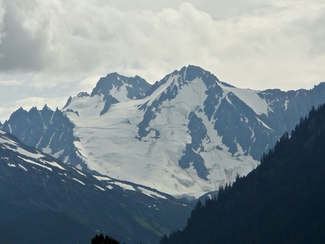
Through snow capped mountains

and gravel road sections with washboards.


We stop at the overlook of the Tatshenshini-Alsek Wilderness area, which was a major trading route between the native tribes of the coastal regions and the interior as well as being a favored summer hunting ground.
Tatshenshini-Alsek Overlook


As we near the coastal areas, we drive over Chilkat Pass which was once tightly controlled by the Chilkat Tribe, the most powerful of the Tlingit peoples. The Chilkats even successfully defeated their control over these trades routes against the white man, that is, until the great influx of humanity during the 1898 Klondike Gold Rush proved to be too much. They had such a wealthy and complex society that John Muir remarked in his Travels in Alaska of all the tribes he had met the Chilkats were superior:

"The Chilcats are the most influential of all the Thlinkit tribes. Whenever on our journey I spoke of the interesting characteristics of other tribes we had visited, my crew would invariably say, 'Oh, yes, these are pretty good Indians, but wait till you have seen the Chilcats.'"
Beginning of Chilkat Pass

Close to the top of the pass


The road follows along the Chilkat River shortly after the summit and re-entering Alaska. Every year in the Fall when the salmon are running, thousands of bald eagles assemble in this area mid October for the annual "Gathering Eagles." Even though it's too early for the big gathering, we do manage to see a few eagles on this stretch of river.

Chilkat River


Soon we are in Haines, Alaska.
Early eagle along Chilkat River

Peter checks out mural on Information Center wall

Marti meets a
local resident

Haines is nestled on one arm (Skagway is on the other arm) of the Lynn Channel, one of the longest and deepest fjords in the world. Although it's neighbor Skagway (main entry point for the Klondike Gold Stampeders to the Yukon) is more favored by the cruise ships, Haines has a better developed community of year around residents. The people of Haines are very friendly and welcoming as they get just enough tourists to still be interested in meeting visitors. In fact, we had one of our best meals in Haines - a potluck organized by the RV Park in which both locals (with fresh crab, prawns, and salmon) and visitors shared their homemade dishes.

Haines on the Lynn Channel


After securing a spot at Oceanside RV Park, we wander around the town to get our bearings. We are especially amused by one building with a Liquor Store on the first floor and an Acupuncture Clinic on the second floor.  We joke that actually the two do go together as an Alaskan form of alternative pain control.
Small boat harbor

Bear's Den Bakery - great for breakfast

Alaskan alternative pain control

We love our view of the Lynn Channel from our campsite.


Although the tides along the Lynn Channel aren't as wide as Turnagain Arm, there's an amazing change between high and low tides. During the low tides, we see many birds and even a bear. In fact, one evening a young bear ventured so close to camp, the owners call the local sheriff who shot rubber bullets at the bear to scare it away. Joyce, one of the owners of the RV Park, tells of a grizzly who learned how to open sliding glass doors and raiding the freezers full of food at night.
Great Blue Huron

Low tide in front of Oceanside RV Park

Bald Eagle checks out tide pools

One day we rent a car and drive out to the 33 Mile Roadhouse for lunch. It's a favorite of both locals and visitors. We share the porch with a group of mountain climbers with their local guide. While there. we notice a man folding the wings of his small plane back and then hitching it to his car and driving away. We all watched in amazement and wondered how well the locking mechanism worked once the wings were snapped back into place.


After visiting the Ranger Station for Chilkat State Park, we decide to take a hike on the Seduction Point Trail just outside of Haines. It's a narrow winding trail through the forest which leads to the Chilkat Inlet. Although there's not much change in elevation gain, it's a challenging trail because of the many exposed roots on the trail and shaky bridges over swampy areas. The view up and down the Chilkat Inlet is well worth the hike.
Beginning of
Seduction Point Trail

Shoreline of Chilkat Inlet

Mountain and glacier across inlet

View towards the south of Chilkat Inlet


A magnificent glacier is plainly visible across the inlet.
Glacier terminal

Close up of blue ice


Our last day in Haines is overcast and rainy, so we decide to try some indoor activities. We start with the Sheldon Museum, which has a beautiful 100 year old apple tree by the entrance. Later we ask  why we didn't see more fruit trees around Haines as they clearly can grow in this climate.  People just laugh and shake their heads as the reason is the biggest pest imaginable - Moose.  A determined moose is a force to behold.
Sign for Sheldon Museum

Raven bringing
Sun to Man

Eagle mask

The Chilkats were a tribe of fierce warriors and many of the exhibits reflect this culture.
Chilkat armor

Carving of Raven

Copper Shield
for a Chief

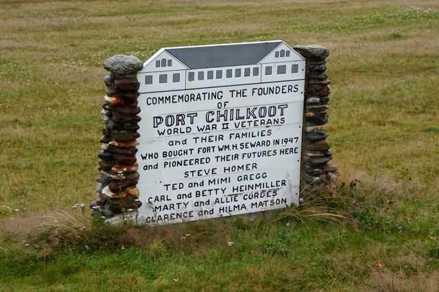
After the museum we walk over to Fort William Seward which was established during Alaska's Gold Rush Era. Today it houses residential homes and shops.
Sign for Port Chilkoot

Former Officers' Housing -
now private residences


The former kitchen building has been converted to a Chilkat Tribal meeting hall. Other outbuildings are artists' studios.
Totem Pole

Tribal meeting Hall

Artist Studio

Haines was a pleasant surprise for us. We really like both the town and the people we met there and plan to return some day.
Goodbye Haines - We look forward to coming back


Tuesday, September 18, 2012

Kluane Wilderness, Yukon

After picking up supplies in Tok, we drive southeast on the Alaskan Highway towards the Canadian border. Before reaching the border, we pass by an overlook of the Athabascan village of Northway. This village was named after a great chief, Walter Northway, who lived to the age of 117. Winter temperatures in this area are extreme, regularly dipping to -40 degrees Fahrenheit (record of -72 F). Maybe surviving these cold winters help retard the aging process...?
Valley View toward Nothway


Not far from the turnoff to Northway, we come to the Tetlin National Wildlife Refuge Ranger Station. The two rangers there are very helpful in identifying some of the plants and berries I've taken photos of. We also learn one ranger is the grandson of Chief Northway. He verifies his grandfather's long life and adds his grandmother lived to be 115. He attributes their long life to good genes and a healthy outdoor lifestyle.
Tetlin Wildlife Refuge Ranger Station

Humm - wild swans
must be common here


After an easy crossing back into Canada's Yukon Territory, we stop and camp at Discovery Yukon Lodgings RV Park. The owner has a vintage 6 wheel drive army truck in which he takes people bear viewing by the nearby White River. Unfortunately, the salmon have just finished their run and the bears have moved on, so we content ourselves with his bear stories.  He points out that they have one small dog on the property. Apparently a few weeks ago there where two small dogs, but one of them got excited about a bear across the highway and ran after it.  Unfortunately, the bear made short work of the dog once the it had invaded his territory.  But not to worry, he tells us, the bears don't wander into the RV Park as they know it's human territory. Whew - glad he told us so I can sleep better.
Yukon Discovery RV Park

Our campsite

Classic Yukoners live here

The next morning dawns to a cool but beautiful day and we enjoy the drive south.
Pickhandle Lake makes a nice rest stop


In passing a small lake, we spy swans preening and sunning themselves. Fortunately the lake has a large parking lot for maintenance vehicles where we park to get better photos of them. The Trumpeter Swans put on a good show.
Small lake with Trumpeter Swans

Wow - they're big

and beautiful birds.

The clear day finally gives us a good view of the St. Elias Range.
St. Elias Mountain Range


As we near Kluane (clue-an-E) Lake, we pass through the small town of Burwash Landing and stop at the Kluane Museum. Although it's a small museum, it has some excellent dioramas of native wildlife.
Welcome to Budwash Landing

Mountain Sheep

Mountain Goat

As we follow along the coast line of Kluane Lake we see a large grizzly browsing along the shore. Of course we have stop and take photos. Peter's able to capture close ups of a large healthy grizzly. Sure glad we're able to take photos at a safe distance. Later on we stop at Cottonwood RV Park and score a great campsite right next to the lake.
Kluane Lake

A good sized grizzly busy munching away

Our campsite on Kluane Lake

That evening we take a walk along the shoreline to pick up driftwood for a campfire. We pass by a large camp of Germans just as a nude man rushes out yelling for a polar bear dip in the cold lake (it's formed by glacier melt water). We all cheer him on even though he doesn't stay for a very long swim. Nope - you won't catch me going for a dip in that cold water.
Evening on the shore of Kluane Lake


That night cold winds from the East whip up surprisingly large waves in the lake and rock the IQ back and forth. We are glad to have electricity and a small heater to keep us warm. It makes us wonder what the winters are like here and helps explain why a town in the area is named Destruction Bay.  In the morning we ask the RV park owner if the wind regularly comes up and night and she admitted they often do. Storms are powerful in this country.

As beautiful as the campground is we decide to move on to the Kluane National Park to do some hiking. We pick up a hitchhiker on the way to the Ranger Station. He has been hiking for several days in the wilderness, but has injured himself and needs a ride back to civilization. He's from Israel and we remark on how far way from home he is. Turns out he lives around Shasta, California and we happen to know some of the same people. He tells us the trails in this wilderness area are the most beautiful he's ever seen and recommends a trail out of the Ranger Station for a day hike.  
Area around Ranger Station at Kluane National Park


The ranger gives us a map and directions how to drive to the trail head. It's a narrow bumpy road which Peter negotiates well and we are both thankful of not encountering any other vehicles ... although the parking lot is surprisingly full. The good weather brings out both Yukoners and tourists alike. So we head up the steep trail to Sheep Mountain (yup - another Sheep Mountain). As is typical in Canada and in the Yukon in particular, there are few if any trail makers. Fortunately, we meet a family from Whitehorse who point out the 5 km marker on the trail.
Peter forging ahead on the trail

A Yukon trail maker

The trail goes this way and that way

The views from the overlooks are magnificent.
View from Sheep Mountain Trail


On our way back down the trail, we stop for lunch at one of the lower outlooks.
Close up of a surrounding mountain

Peter unpacks lunch

Glaciers tumble out of the mountains

View from our lunch stop


After the hike we decide to drive to Kathleen Lake Campground which is further south but still in the Kluane National Park. On the way we are treated to clear views of the St. Elias Range.
St. Elias Mountains


Although it's later in the day, we find a nice campsite and take a short hike down to Kathleen Lake after dinner for a nice end to a great day.
Kathleen Lake


About Me

My photo
Retired and enjoying life.