After gathering supplies and replacement headlight bulbs for the Navion, we head north from Flagstaff to the
Bonito campground. We are lucky to be their first campers as they are just opening for the season. It's a great little campground and we plan to return again. We get up early to spend the day touring the loop starting at
Sunset Crater Volcano National Monument and winding through
Wupatki National Monument.
 |
| Turnoff for the campground |
|
 |
| Our home for two nights |
|
|
Sunset Crater erupted around 1100 AD as scientists have figured from studying tree rings. The eruption devastated a large area of many square miles. The surprising part is while scientists have found buried homes and buildings of the native population in the area at the time, they haven't found any indications of the blast killing any humans. Apparently, the residents took the impending earthquakes as a bad omen (which they were), packed up their belongings and left. Some even took the roof beams of their homes with them.
 |
| Road to Sunset Crater |
|
 |
| Short nature hike around the cinder cone |
|
|
Just a little farther up the road is Wupatki, which occupies the high plains on the eastern side of the
San Francisco Peaks.
Wupatki was first inhabited around 500 AD by the Sinagua peoples. In the Hopi language, Wupatki means "tall house" reflecting a multistory pueblo with over 100 rooms. Since Wupatki was outside the devastation zone of the Sunset Crater, it's population grew from people fleeing the impending eruption. Our first stop is Wukoki ruins.
 |
| Entrance to Wupatki |
|
 |
| Turn off for Wukoki |
|
 |
| Sandstone rocks look like monsters guarding the ruins |
|
Wukoki stands out in the open occupying a rise on the plain making it visible for many miles. Archeologists believe it was a trading center and a destination for travelers. Since we are used to seeing cliff dwellings, it surprises us to see one so unprotected. It must have been built and occupied during a time of peace and plenty.
 |
| Wukoki ruin |
|
 |
| Main tower is three stories high |
|
 |
| stonework used in construction |
|
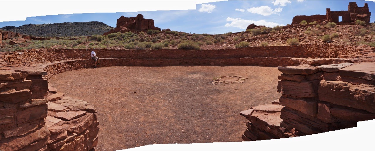
The crown jewel in this National Monument is Wupatki Pueblo itself which housed over 1000 people at it's peak. It's a complex pueblo with extensive residences, a ball court, blow hole, and large community center.
 |
| Turn off for Wupatki Pueblo |
|
 |
| The main rooms of the pueblo |
|
 |
| stone walls up to 3 stories tall |
|
After checking out the main rooms, we head down the trail to the ball court, blow hole, and community center.
 |
| Trail head sign |
|
 |
| trail to ball court |
|
 |
| Peter checks out cool air from blow hole |
|
 |
| Peter sits on the bench at the large community gathering area |
|
|
|
 |
| Overview of Wupatki Pueblo |
|
|
|
The next stop is Citadel Ruin which is a smaller settlement built on top of a steep hill. It has not been excavated or rebuilt.
 |
| Sign for Citadel |
|
 |
| Trail to the ruin |
|
 |
| Large sink hole on the way up to the ruin |
|
The amazing part of this ruin is the view which affords 360 degree vistas of the surrounding area including many of the nearby settlements of the time.
 |
| View from Citadel Ruin |
|
|
|
Lomake is the final set of ruins in the park which consists of several smaller buildings along a box canyon. Archeologists believe this was a farming community.
 |
| Lomaki Ruin sign |
|
 |
| Peter checks out one of the buildings |
|
 |
| Box canyon |
|
 |
| Two close buildings |
|
 |
| small doorways |
|
|
The following day we say good-bye to the beautiful San Francisco Peaks to head north bound for the Hopi Mesas.


There should be a "LIKE" button on all those photos!!
ReplyDelete