Friday, March 30, 2012

Gila Cliff Dwellings National Monument

We get an early (for us) start and drive a few miles up the road to the Gila Cliff Dwellings National Monument Visitor's Center. After getting information from the rangers and wandering around the exhibits, we drive to the trail head for the cliff dwellings.  There another ranger describes the trail and the rules as well as some of the history of the dwellings.

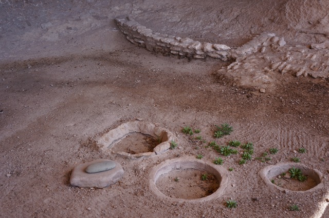
The dwellings were built over 700 years ago in the 13th century by the Mogollon people. At that time the southwest had endured many years of a devastating drought which had brought many cultures to their knees. Many small bands searched the land for enough food and water to survive.  It's estimated that about 40 people were in the group that wandered up this narrow canyon to find refuge in the natural south facing caves. These dwellings are very unusual for the Mogollon culture, as they didn't normally build pueblo style structures.
Sign at trail head

Narrow canyon with small stream


We are lucky to be here on such a lovely day. Temperatures are in the mid 70's - perfect for hiking.
Good sign to keep people on the trail

Our first glimpse of the caves


There are a total of six caves. All except Cave 6 have various kinds of structures in them.  Some caves were for common areas for cooking and enjoying communal living.  Others were for ceremonial or religious purposes. The buildings in these were built with more care than elsewhere.  Also, there are caves with individual rooms for different family groups.


As you look at these photos, you may notice that almost all the caves have black ceilings.  The buildings all stop short of the roof of the caves to allow smoke to escape from cooking and heating fires.
Communal cooking pits designed for
round bottomed pots called ollas

Cave ceiling blackened with soot


The next few photos give an idea of how these dwellings were built. We were surprised to learn these dwellings were only occupied for one generation.  No one knows why they left.  Perhaps they had depleted their food sources, or just simply wandered off to join other pueblo tribes. Several of the other pueblo tribes count Mogollon peoples as part of their ancestry.
Hand build stone walls with mortar

Logs for ceiling and floor supports were hauled from the Gila River basin

Detail showing stones and log supports

The natural south facing caves acted as passive solar cooling and warming.  The sun rays were prevented from entering the caves in the hot summer months, but penetrated deep within during the cold winter months.


It's had to image whole families living in one of these rooms, especially in comparison to how we live today.
Room with basket and bowl

Room with fireplace

Room with cooking hearth

Once we have finished viewing all the caves, it's time to exit down a ladder and hike back on the return loop of the trail.
Ugh! Why do all ruins have ladders?

Inaccessible Cave 6

Cliff stained by storm runoff


View of Gila River from return trail

Mexican Wolf in small exhibit by trail head

Our trusty steed awaits us
We saddle up the Navion and drive to the Lower Scorpion Campground (inviting name) to see some pictographs painted in ocher on a cliff face.  No one knows what these pictographs mean.  However, I can't resist the urge to take a stab at reading them:
Come to the party

You'll need to cross two rivers to get there

It's the dwelling by the sharp cliffs


Come and we'll have a great time dancing 'til dawn!


No comments:

Post a Comment

About Me

My photo
Retired and enjoying life.